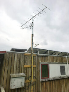
High Country Audubon Society Motus Tower

High Country Audubon Society is the proud owner/operator of our first of what will eventually be a series of Motus Towers in the mountains of North Carolina to detect and identify birds migrating through the region. The tower is located on the Appalachian State University Sustainability Farm in Ashe County, NC. Many thanks to retired Astronomy Professor Emeritus, Dr. Richard Gray, a long-time HCAS member, who used his expertise to help make this happen. Our thanks also go out to Motus Wildlife Tracking System (Motus.org) and Birds Canada (BirdsCanada.org) for making all of this possible.
Birds detected by our Motus Tower
We have had a pretty exciting start with our Motus Tower, detecting four birds since the Tower went online on August 9, 2024.
Click on the links below to see the tracks for the birds we have detected.
- Bobolink detected on 09/20/2024
- Wood Thrush detected on 10/1/2024
- Tennessee Warbler detected on 10/5/2024
- Wood Thrush detected on 10/5/2024
Four birds in just over two months may not seem like a lot, but you need to realize that only birds with tags are detected. We only see the birds with tags who happen to come close enough to our tower. Each bird detected adds valuable data into the amazing world of bird migration. By understanding migration patterns for each species, we can better protect the environments that the birds need to survive. Our longer-term goal is to add additional towers in strategic locations to gather more data. The more towers that are erected, the more willing researchers are to spend the money on tagging more birds.
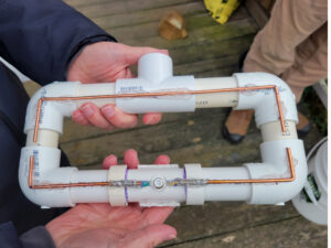
On October 15, 2024, we added a fourth antenna to our tower (see photo below), adding visibility to the North for the 434 MHz frequency. This antenna was built by Dr. Richard Gray. It doesn’t look fancy, but it should increase the odds of detecting tagged birds in our area. Our initial test shows it giving excellent coverage. We have a plan to add two more antennas to get even better coverage.

To see all data for our first tower, use the link below.
Click for all data for our Motus Tower
Want to Learn More about Motus Towers?
The Motus Wildlife Tracking System (Motus: Latin for movement or motion) is an international collaborative research network that uses radio telemetry to track small flying organisms (birds, bats, and insects). When compared to other technologies, automated radio telemetry currently allows researchers to track some of the smallest animals possible, with high precision, over great distances. The system enables a community of researchers, educators, organizations, and citizens to undertake impactful, cost-effective, research and education on the ecology and conservation of migratory animals.
The antenna attached to a bird when tracking with Motus is generally very small and lightweight, designed to minimize impact on the bird’s behavior and health. Typically, the tracking device consists of a nano-tag with a small antenna.
Key Details:
- Antenna Length: The antenna is usually around 12-15 cm (4.7-5.9 inches) in length. This length varies depending on the specific model and the species being tracked.
- Weight: The entire tag (including the antenna) usually weighs between 0.2 and 1 gram, making it suitable for even small bird species without interfering with their natural behavior.
- Tag: The tag itself is often affixed to the bird using a harness, adhesive, or similar method, and it emits a unique signal that can be detected by the Motus towers within a specific range.
The size and design are specifically chosen to ensure that the bird can continue its natural activities like flying and foraging without being encumbered by the tag. The Motus system uses this setup to track the movements of birds, bats, and insects over long distances across a network of receiving towers.
Bird Migration Explorer
National Audubon Society has created a Bird Migration Explorer to show migration paths of birds in the America’s. To view migration data for specific bird species, click the link below and then select a species.

